
NOAA: Autumn and November both warmer than average in the United States
U.S. sets record with a dozen billion-dollar weather disasters in one year
November and the September-November autumn season were warmer than average across the contiguous U.S., according to scientists at NOAA’s National Climatic Data Center (NCDC) in Asheville, N.C. Precipitation totals across the country were also above average during November, but near the long-term average for the autumn season.
The average U.S. temperature in November was 44.3 degrees F, or 1.8 degrees F above the 1901-2000 long term average, while the average autumn temperature was 55.5 degrees F or 1.3 degrees F above average. Precipitation averaged across the nation during November, was 2.33 inches or 0.21 inch above average. The severity of drought conditions lessened across northern Texas, where near-normal precipitation was observed for the month, but in other locations throughout the state, drier-than-normal conditions meant drought conditions remained unchanged.
This monthly analysis, based on records dating back to 1895, is part of the suite of climate services NOAA provides.
Billion-Dollar Disaster Update
- To date, the United States set a record with 12 separate billion dollar weather/climate disasters in 2011, with an aggregate damage total of approximately $52 billion. This record year breaks the previous record of nine billion-dollar weather/climate disasters in one year, which occurred in 2008.
- These twelve disasters alone resulted in the tragic loss of 646 lives, with the National Weather Service reporting over 1,000 deaths across all weather categories for the year.
- Previously only 10 events were reported; the two new billion-dollar weather and climate events added to the 2011 total include:
-
- The Texas, New Mexico, Arizona wildfires event, now exceeding $1 billion, had been previously accounted for in the larger Southern Plains drought and heatwave event. This is in line with how NOAA has traditionally accounted for large wildfire events as separate events.
- The June 18-22 Midwest/Southeast Tornadoes and Severe Weather event, which just recently exceeded the $1 billion threshold
- The Texas, New Mexico, Arizona wildfires event, now exceeding $1 billion, had been previously accounted for in the larger Southern Plains drought and heatwave event. This is in line with how NOAA has traditionally accounted for large wildfire events as separate events.
- NOAA continues to collect and assess data regarding several other extreme events that occurred this year including the pre-Halloween winter storm that impacted the Northeast and the wind/flood damage from Tropical Storm Lee. Currently, these events are not over the $1B threshold using the available data.
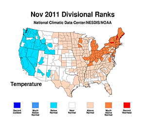
November 2011 temperature "divisional rank" maps.
Download here. (Credit: NOAA)
U.S. Climate Highlights – November
- During November, the eastern half of the country experienced above-average temperatures. The warmest temperature anomalies, which is the actual temperature compared to the 20th century average, occurred across the Midwest, Mid-Atlantic, and Northeast, with13 states across these areas having November temperatures among their 10 warmest on record.
- Cooler-than-average temperatures were present across parts of the West and Northwest, with six states having November temperatures below average.
- Precipitation during November was variable from region to region. Several storm systems brought above-average precipitation to the Ohio Valley and parts of the South, where eight states had precipitation totals ranking among their 10 wettest.
- Below-average precipitation was observed across parts of the West, and parts of the northern and southern United States. Minnesota tied its ninth driest November on record, with only 0.35 inch of precipitation – 0.95 inch below average.
- As of November 29, about six percent of the contiguous United States remained in the worst category of drought, called D4 or exceptional drought, a decrease from the nearly 9 percent at the beginning of the month. Drought conditions lessened across Arkansas, Kansas, and Oklahoma, where there was above-normal precipitation during November.
- The 2011 North Atlantic hurricane season ended on November 30, after an above-average season for the basin. This year’s 19 named storms tied with three other years (2010, 1995, and 1887) as the third busiest season on record. Seven of the named storms became hurricanes, which is near average. Only Tropical Storm Lee and Hurricane Irene made landfall in the United States.
- A large and powerful extratropical cyclone slammed into western Alaska in early November, with extremely high tides, strong winds, heavy rain, and blizzard conditions. Winds gusted to over 80 mph and the storm surge topped eight feet, marking the strongest storm to impact the region in decades.
- A powerful Santa Ana windstorm whipped through mountain passes and canyons across the West and Southwest beginning on November 30 and continuing into December. The near-hurricane force winds were driven by the interaction between a strong high pressure system in the northwest and a low pressure system moving through the southwest. Portland, Ore., recorded its second highest maximum atmospheric pressure reading (30.76”) ever.
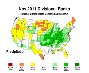
November 2011 precipitation "divisional rank" maps.
Download here. (Credit: NOAA)
U.S. Climate Highlights – Autumn
- During the autumn period, the United States, as a whole, experienced above-average temperatures with a nationally averaged temperature of 55.5 degrees F. This was 1.3 degrees F above average.
- Most states had autumn temperatures, which were near to above average. Massachusetts, Rhode Island, and Vermont had their record warmest fall. Eight other states had an average temperature that was one of the ten warmest on record. Conversely, four states in the Southeast and along the Gulf Coast had below-average autumn temperatures.
- The nationally-averaged precipitation total during autumn was near average. Very wet conditions were present from the Ohio Valley and into the Northeast. Parts of the upper Midwest were drier than average, and Minnesota had its third driest autumn on record.
U.S. Climate Highlights – Year-to-Date
- For the first 11 months of 2011, the U.S. was warmer than average. Much of the warmth was anchored across the Southern Plains and along the Eastern Seaboard. Delaware and Texas were record warm for the January-November period with statewide temperatures 3.2 degrees F and 2.5 degrees F above their long-term averages respectively. Only Oregon, South Dakota, and Washington were cooler than average during the period.
- Nationally-averaged precipitation totals for January-November were near the long-term average, but significant differences between regions existed. Texas was record dry for the11-month period, with a statewide precipitation total of 12.0 inches which stands as 14.0 inches below average. For the year-to-date period, the Ohio Valley and Northeast had very wet conditions with Connecticut, Massachusetts, New Jersey, New York, Ohio, Pennsylvania, and Vermont each having the wettest January-November period on record.
- For the year-to-date period, the national Climate Extremes Index ranked as the 12th highest value on record, due to a large area of the country experiencing extremes in warm temperatures and both high and low precipitation totals. The Climate Extremes Index (CEI) is an index of extremes in temperature, rainfall, dry streaks, drought, and tropical cyclones. On a regional level, the Northeast and the South had their second highest January-November CEI values.
NCDC’s monthly reports are based on preliminary data, which are subject to revision. Additional quality control is applied to the data when latereports are received several weeks after the end of the month and as new scientific methods improve NCDC’s processing algorithms.
NOAA’s mission is to understand and predict changes in the Earth's environment, from the depths of the ocean to the surface of the sun, and to conserve and manage our coastal and marine resources. Join us on Facebook, Twitter and our other social media channels.